Résumés du 6ème colloque de SEECHAC qui s’est tenu du 2 au 4 Novembre 2021, Leipzig University, Bibliotheca Albertina.
MONIKA ZIN, Sächsische Akademie der Wissenschaften, Leipzig / Universität Leipzig.
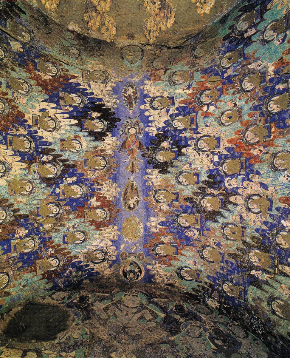
Mountains inside the Living Stone – The Magical Hillscapes of Kucha Cave Vaults

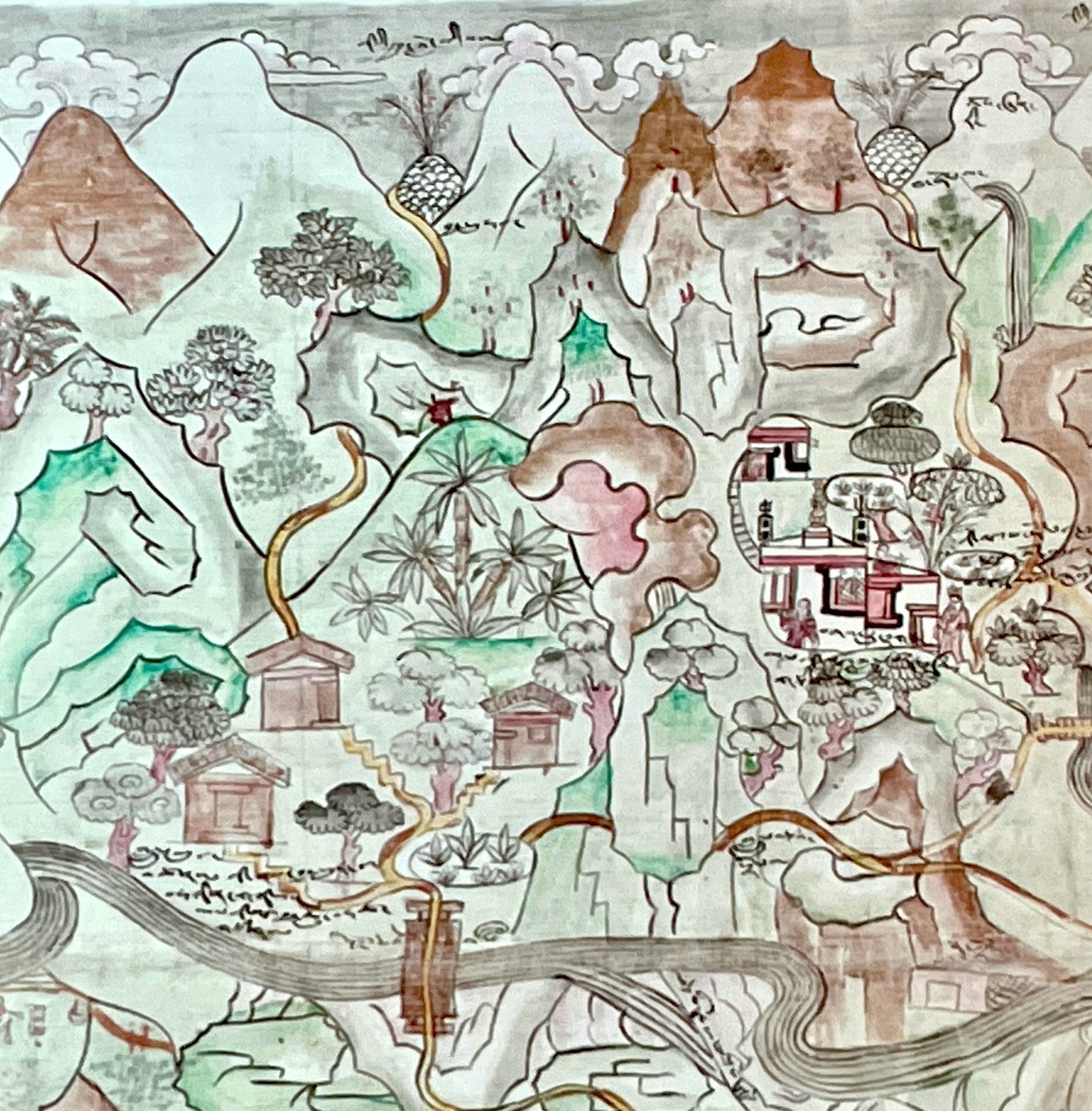
Based maybe on Indian or Iranian concepts of heavenly, paradisiac landscapes, the paintings in Kucha show a unique feature: over centuries they use mountainous landscapes as a backdrop and frame for all the depictions on the vaulted ceilings, as an all-encompassing setting. Inside a cave the vaults show us a mountainscape.
Leaving aside proposed Buddhist notions this motif may contain, the paper focuses on what the paintings show.
The landscape is a magical wilderness. Humans and animals of daily life (known from the narrative representations) are not represented here, but various strange animals are which were obviously unfamiliar to the artists: monkeys have feet like birds. The pictures are influenced by ideas from India, or rather about India. They not only show meditating ṛṣis in their caves or huts but also exercises in penance groves which were actually severely criticised in Buddhist sources. Genii are to be met there, but so are the pretas. Such small scenes describable as “genre scenes from the woods” tell us more about the imaginations of the Tocharians than Buddhist texts.
JI HO YI, Sächsische Akademie der Wissenschaften, Leipzig / Universität Leipzig.
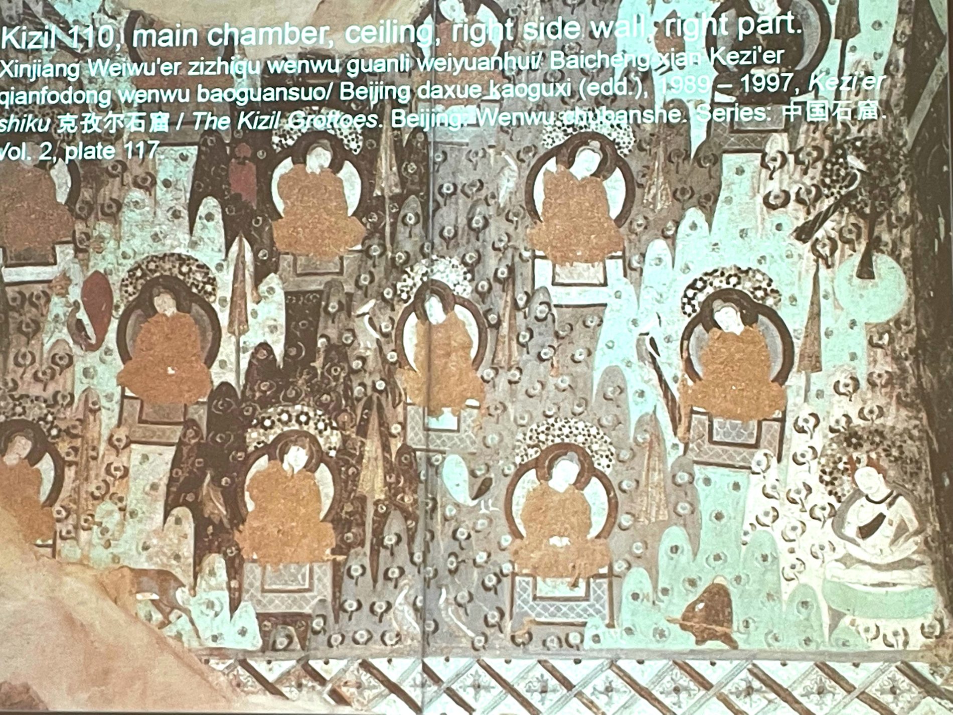
Sacred Mountains Where Enlightened Beings Reside: Rows of Buddhas and Pratyekabuddhas in Kucha and Dunhuang
Rows of Buddhas sitting alone on a throne in a mountain decorate both sides of the barrel vault of the Kizil Cave 110. This scene is different from the usual narrative scenes on the barrel vaults in other Kizil Caves, having no accompanying figure next to the Buddha. Other examples can be found among other wall paintings in Kizil and Kizilgaha Grottoes in the territories of the ancient Kucha kingdom. In addition, Dunhuang Cave 285 contains a row of meditating figures, each sitting in a mountain cave. Maria A. G. Th. Kloppenborg offered a clue to interpreting this fascinating landscape, writing that the five hundred pratyekabuddhas reside on the same slope in the Mountain Gandhamādana in the Himalaya Mountains after achieving enlightenment. The collective residence of pratyekabuddhas shows a close resemblance to the monastic community.
It is not easy to recognise whether the figures are samyaksaṃbuddhas or pratyekabuddhas due to the scratch around the figures’ heads if those are indeed samyaksaṃbuddhas, these figures filling the barrel vault could have resulted from the idea that many Buddhas may exist simultaneously in multiple realms. The manuscripts found in nearby regions and accounts from Kumārajīva’s biography surviving in Chinese show the existence of Mahāyāna belief in Central Asia earlier than 7th century CE.
The image of the numerous enlightened beings in the mountains is noteworthy in the light of the walls covered with mere repetition of Buddha icons located in the centre of the circular nimbus, so-called thousand Buddhas. While it is difficult to identify which type was earlier than the other, the repetition of many Buddha icons supports the idea that the local believers were aware of many Buddhas filling the space. This presentation will show this image in the context of local Buddhism and the development of the iconography.
FANG WANG, Sächsische Akademie der Wissenschaften, Leipzig/Ludwig-Maximilians-Universität München.
The “Stole-Dance” Figure as Part of Heavenly Landscapes and Representation of Secular Life along the Silk Road
 The article shed light on the spread of “stole-dance” _figures, a stylised dance portrayal found in art of different places along the Silk Road. It is characterised by male and female dancers standing on one leg in twisted body posture, each holding a long stole in hands. Either identified as celestial musicians or as secular entertainers, the stole-dance figure functions as integral part of heavenly landscape or profane life representations. It symbolises the pure joy in narrative as well as in ornamental scenes, regardless of the various religious and profane contexts. The prevalence of this sophisticated imagery dates back to about the 5th century CE and it is attested in Sogdiana, the Tarim Basin, and Inner China. Among them, the latter two places have preserved the most portrayals of “stole-dancers. In Kucha, they are incorporated into the first and the second Indo-Iranian style paintings of the Buddhist caves from the 5th CE century on, whilst various depiction are discovered in the funerary art of Sogdian immigrants in China, dated mostly to the 6th century CE. In previous studies, they have been classified as exotic “Sogdian whirl” dancers, who were transformed into celestial dancers in Buddhist paradise illustrations in the following centuries. However, in the commonly believed home of the dance in Sogdiana, such dancing figures are rarely evidenced and they do not predate the Kuchean paintings, neither.
The author aims to clarify the Iranian and Indian cultural elements of the “stole-dance” portrayal, and furthermore to suggest the formation of the “stole-dance” in Central Asia. It will be proposed that Kucha should be considered one of its possible birthplaces.
OSMUND BOPEARACHCHI, Centre for Scientific Research, École Normale Supérieure, Paris.
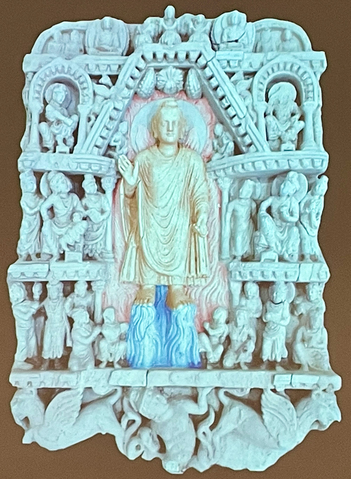
The Buddha Performing the “Twin Miracle” Creating the Spatial Cosmos
 The Buddha performed different types of miracles in different places and on different occasions. The double emission of fire and water from his body (yamakapātihāriya) and the multiplication of himself in the sky are the most popular miracle in Gandhāran art. According to the literary sources available to us, this “Twin Miracle” was performed at least three times. The first attested “Twin Mircale” was performed during the first week after his “enlightenment” (Nidānakathā, p. 200). This episode is not depicted in any school of Indian art. The same “miracle” was performed at Kapilavastu before Sakyas who are proud by nature, and stubborn in their pride (Nidānakathā, p. 220-1). After being challenged by a group of heretics, the Buddha performed in Śrāvastī the double emission of fire and water from his body and the multiplication of himself in the sky, so this was the third occasion. It is considered to have been Gautama Buddha’s greatest miracle and something that can only be achieved by fully enlightened Buddhas. The “Twin Miracle” also called the miracle of Savatthi (Pāli), or the miracle of Śrāvastī (Sanskrit). There are two major versions of the story which vary in some details. The (Pāli) account of the miracle is found in the Pāli Dhammapadāṭṭhakathā and the Sanskrit version in the Prātihāryasūtra of the Divyāvadāna. In the light of a previously unpublished sculpture from the Gandhāra, this paper attempts to examine how the landscape is used to highlight Gautama Buddha’s greatest miracle, far more wonderful than any performed by his disciples. The layout of the new sculpture, compared to all other known reliefs from Gandhāra and elsewhere, is strikingly reminiscent of the layered vision of the cakravāla cosmology: it vividly depicts the underworld; the world of manuṣyas and the realm of devas and bodhisattvas.
ROBERT SCHULZ, Freie Universität Berlin / Sächsische Akademie der Wissenschaften, Leipzig .
The We and the Other: Representations of Cultural Landscapes in the Iconography of Central Asia at the Transition between Late Antiquity and Early Middle Ages
 The historical records of the so called Iranian Huns in Central Asia are very limited and their interpretation provokes even more questions. In contrast to that the archaeological material reveals many hints indicating a period of remarkable exchange, reflecting manifold art historical connections traceable back to India, the Roman West, the Sasanian Realm or the adjacent step regions. In such a context it should not come as a surprise that these works also show people foreign to the spectator – shaping the imagination of distant lands with help of images of “the Other”.
These images were usually not ad hoc inventions, they depended on older traditions, loaded with imaginations not always easy to understand for the contemporary observer.
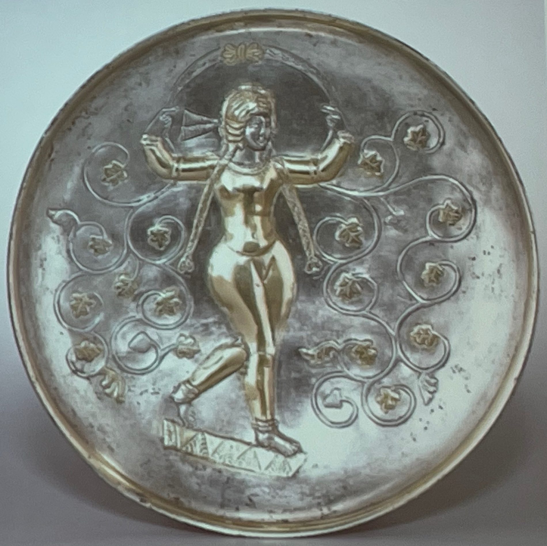
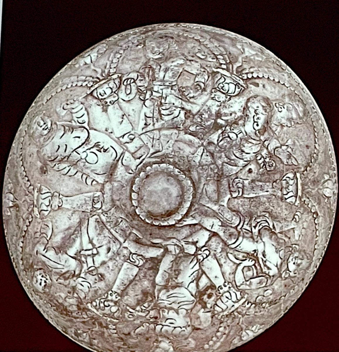
In my presentation I intend to explain some aspects of the emergence of the iconography of “the Other” in Central Asia with help of Indic narratives mirrored in the political circumstances of the 5th century. For this I will follow two traces: the first is related to a silver bowl belonging to the period of the Iranian Huns that uses templates we find in much later representations of “foreigners” in the murals of Old
Samarkand. The second: by connecting the iconography of the four heavenly kings (caturmahārājas) as depicted in the murals of Kucha with the worldly rulers of the Alchan from the North-West of the Indian Subcontinent.
ZHAN ZHANG, University of Oxford.
The Scribal Landscape across the Tarim Basin: A Comparative Study of Secular Documents in Tocharian and Khotanese
 Ever since the discovery of Tocharian and Khotanese, two previously unknown languages unearthed from the ruins of the Tarim Basin in the late nineteenth century, generations of scholars have devoted a great deal of effort to the elucidation of their linguist aspects, and paid close attention to manuscripts of religious contents for their regularity and completeness. Secular documents, which are often fragmentary and lack parallels in other languages, received only superficial treatment.
In the past few years, inroads have been made in the systematic treatment of the largely understudied secular documents in Tocharian and Khotanese. Due to the linguistic barrier and the division of the field, however, the connection between these two sets of documents has not been adequately explored.
In this paper, I shall lay bare the similarity and parallelism between Tocharian and Khotanese secular documents of several genres, such as contracts, orders, and patrol rosters, in terms of terminology, formulae, and diplomatics. These shared features point to a common scribal convention current in Kucha and Khotan, the two political centers of the northern and the southern rim of the Tarim Basin respectively, which were under the same influence of great powers beyond the Tarim Basin. I shall trace this common convention, or at least a part of it, back to India, and assess the hypothesis of the Kushan prototype for the origin of this convention.
STEFAN BAUMS, Ludwig-Maximilians-Universität München.
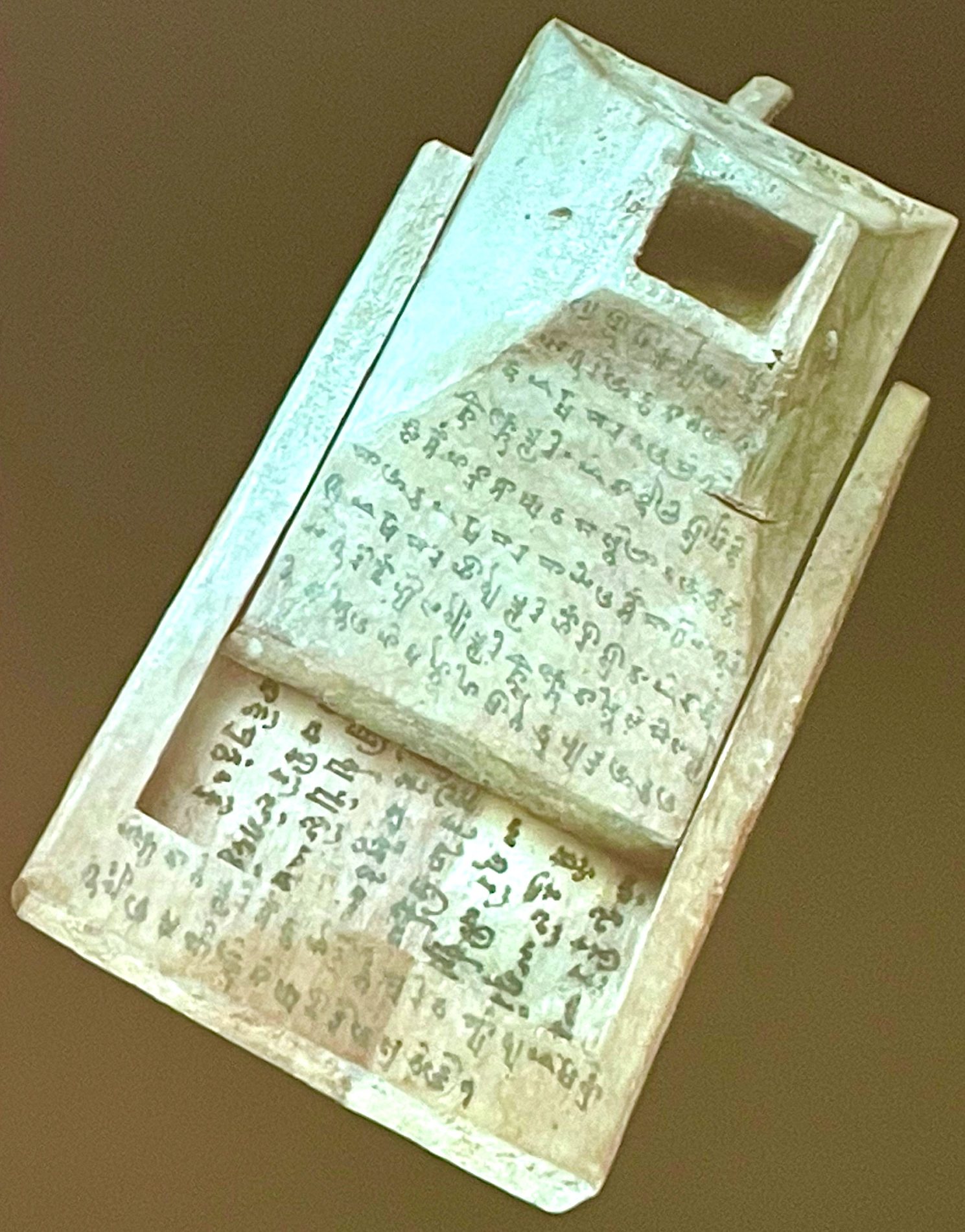
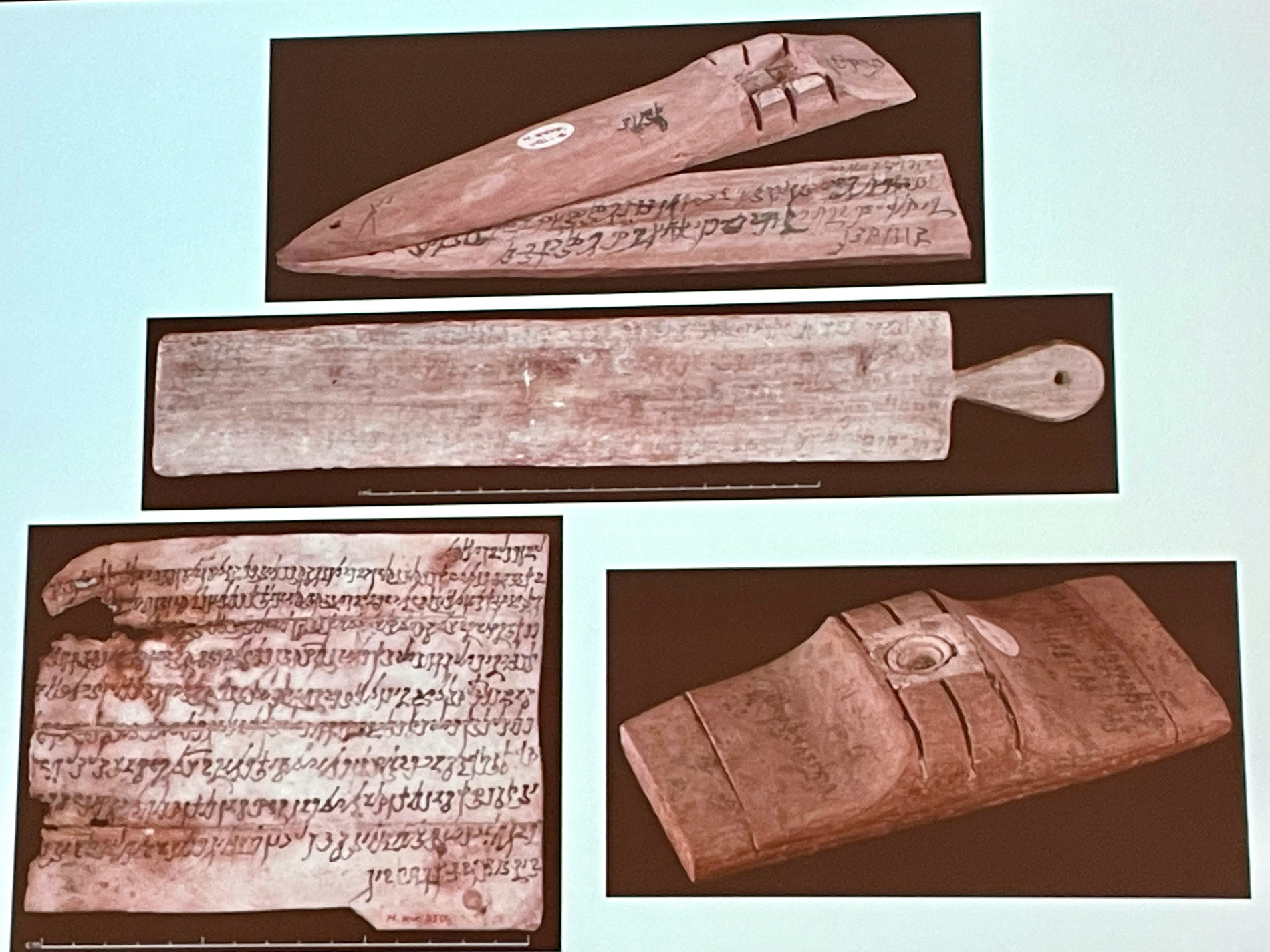
Three New Documents from Ancient Niya
 The site of Niya on the southern Silk Road, a settlement in the Krorayina kingdom bordering on the Khotan kingdom in the west, has yielded almost one thousand administrative and legal documents on wood, leather and paper. Combined, they paint a detailed picture of life in a Silk Road community in the 3rd and 4th centuries CE. This presentation will introduce three unpublished documents from Niya in the Schøyen collection. They are of the rectangular type that usually consists of an undertablet containing the body of the document and a cover tablet containing (where necessary) the end of the body on its inner and addressee information on its outer side. One of the documents (4579/2) is completely preserved and documents the acquisition by the monk Śronasena of the slave Ramaśri in exchange for a camel. Of the second document (4579/1/2) only the undertablet is preserved. It records arrangements for the marriage, in year 25 of king Mayiri (second half of the 3rd century CE), of a certain Lýimirke and Suhapriya, the dowry consisting of a non-free woman Cog̱aroa, a saddle and a horse. The third document (4570/1/1) consists of a cover tablet only, giving the names Lýimu and Lýimira as addressees and preserving only a small portion of unclear body text on its reverse. This cover appears to have been reused for a personal letter from a certain Mitravarma to his friends Kacyika and Taṃcg̱o, written across its outer side. These documents thus illustrate two different textual types and provide rich new glimpses of life in the Niya oasis. After discussing them individually, this presentation will situate them in the broader landscape of human affairs known from the existing body of Niya documents.
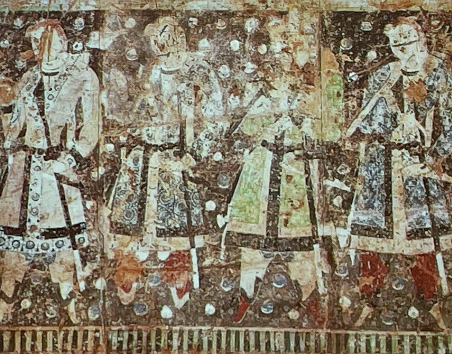
MARIACHIARA GASPARINI, University of Oregon, Eugene.
Tailoring Tocharian Clothing: A Structural and Textile Analysis
 The so-called Tocharians donors portrayed in the Kucha caves wear outfits that are commonly recognized as “Iranian.” Nonetheless, their clothing’s tailoring patterns and textiles present local adaptations of imported materials and styles, which have been often confused as “Sasanian.” Except for the article on Queen Svayaṃprabhā’s dress by Jorinde Ebert (Riggisberger Berichte 9, 2006), who has provided some insights on the topic, to date, a systematic study on Tocharian clothing has not yet been published. The single- or double-lapel robes worn respectively by the sword-bearers and other upper-class people depicted in the caves are similar to Turkic models widely used in Central Asia at the time. Nonetheless, the royal female and male outfits seem to be local creations. This paper discusses the structural features of the Tocharian costumes by analyzing silk and wool specimens from and beyond the Tarim Basin (dated to between the 3rd to the 7th centuries) and reconstructing the tailoring patterns. The properties of a textile (such as material, weight, size, directionality, durability, softness, etc.) can suggest the tailoring pattern of an outfit, but also provide information regarding the depiction and variation of the textile itself in a painting and, thus, the stylistic standards of the pictorial composition. In contrast to the Tocharians’ identical, template-made facial features, the tailoring patterns and the textiles used, as depicted in the caves, visually address the different ranks of the donors.
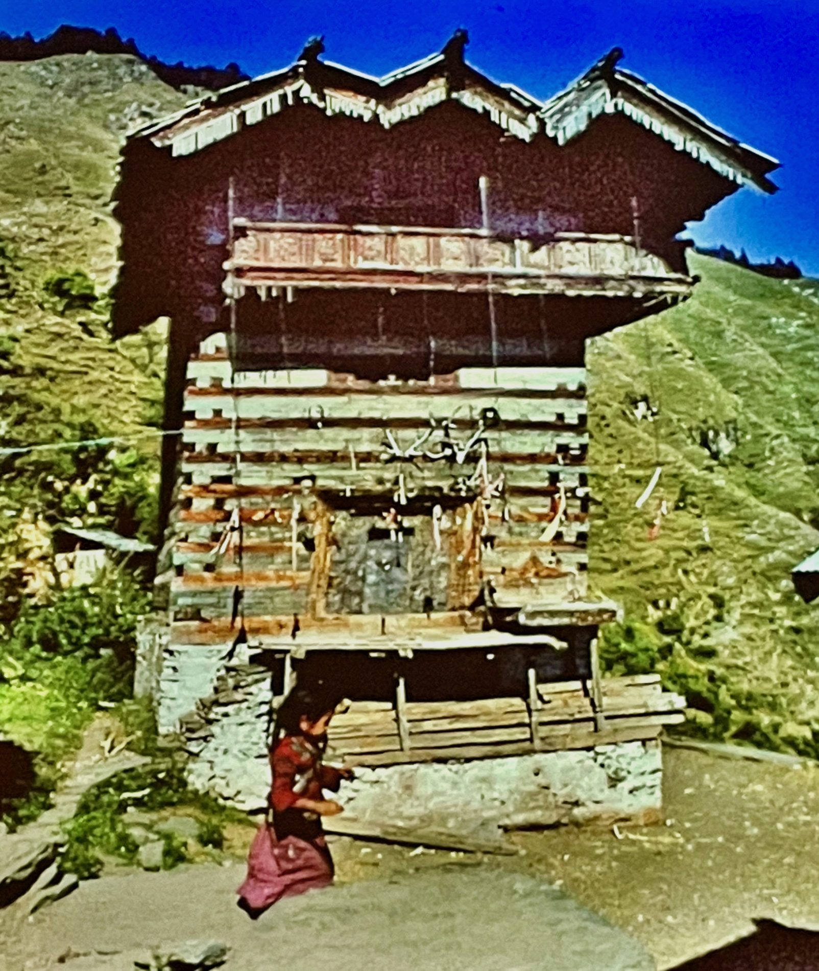
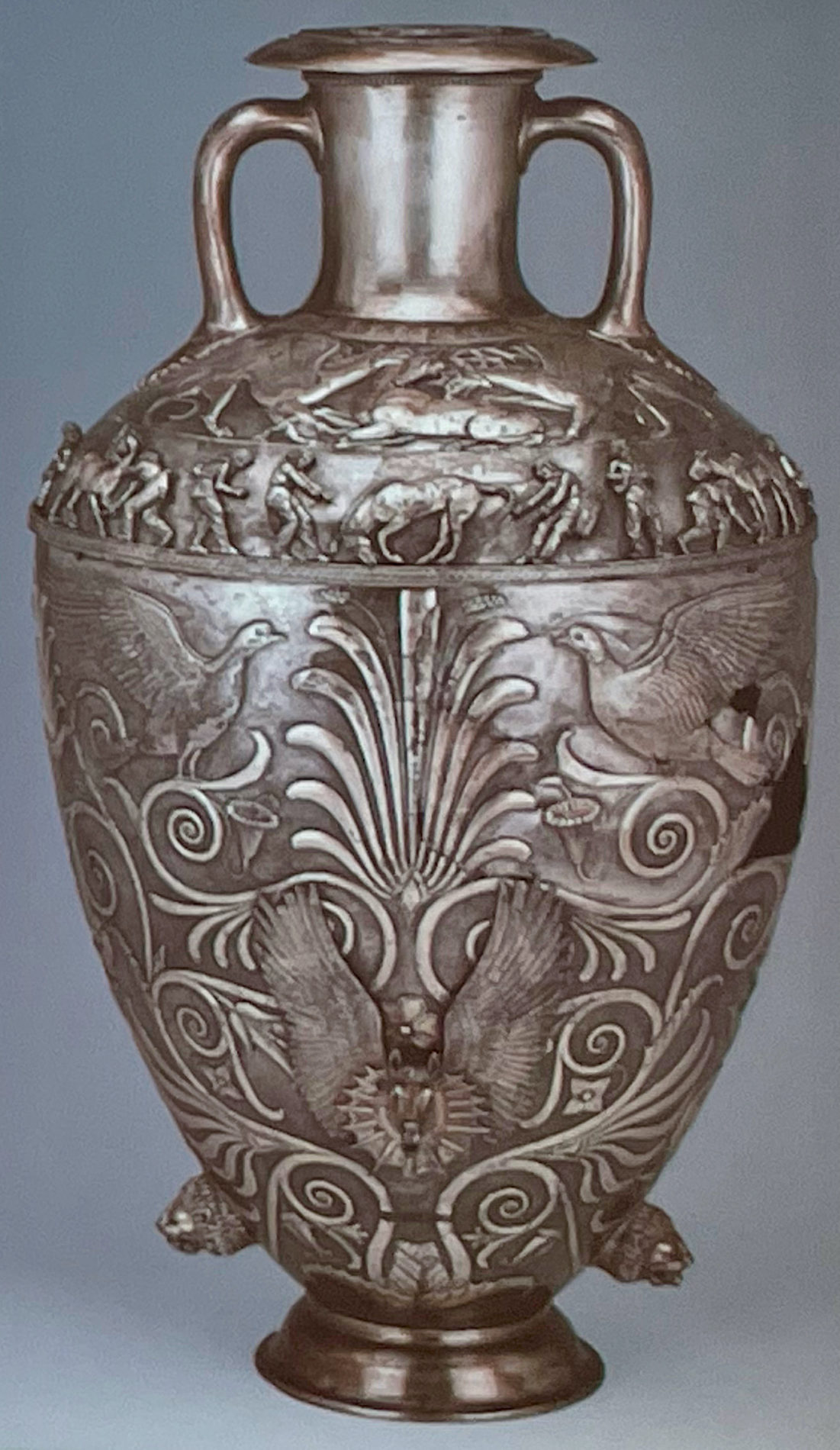
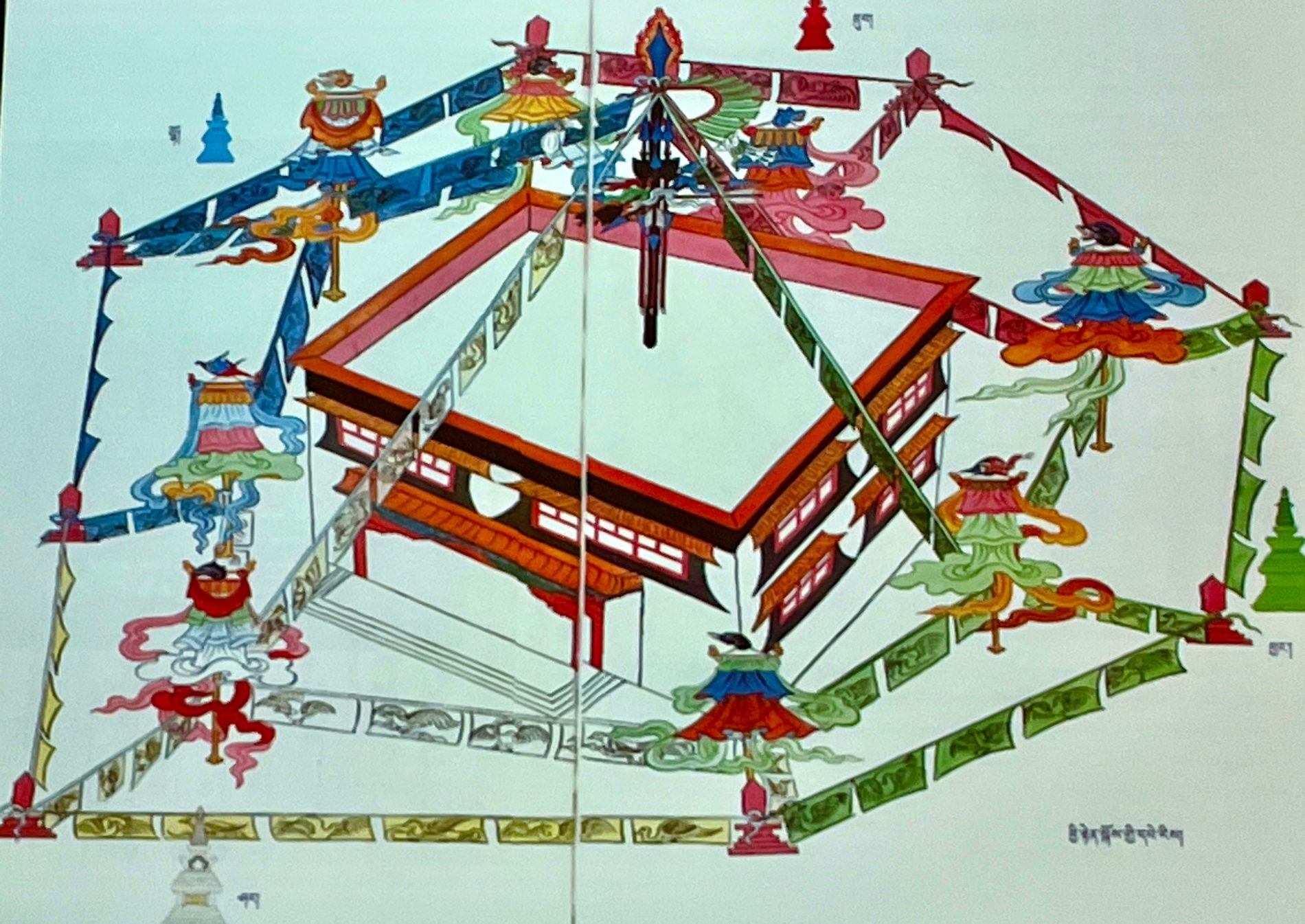
ASTRID KLEIN, Sächsische Akademie der Wissenschaften, Leipzig / Universität Leipzig.
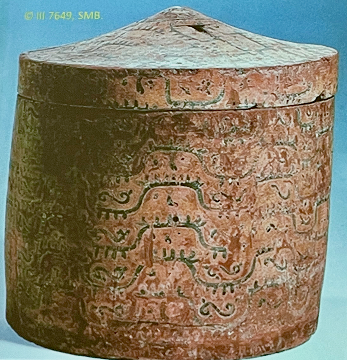
The Imitation of a Cloud-and-Animal Silk Painted on a Reliquary Box from Kucha
 The investigated wooden reliquary box (III 7649, SMB AKu) was discovered by the Fourth German Expedition (1914) in a cave high in the mountains of the Buddhist Kizil Grottoes (Kucha, Xinjiang). Its contents consisted of charred human bones wrapped in a piece of raw leather. The discoverer Albert von Le Coq therefore called it an ash container and interpreted its place of discovery as a burial place for wealthy or pious people in Kucha. Le Coq also suggested that the painted surface depicts a mountain landscape inhabited by animals (stags, snakes, lions), imitating a bronze or brass object that Le Coq says is decorated with coloured gold and silver ornaments. Although Le Coq’s comparison could apply, e.g. for silver objects of Iranian art, which show freely arranged animals in a diamond-shaped mountain landscape, compared to the landscape representation of the barrel-vaulted ceilings in the Kucha caves, this is completely different from the meander lines and the regularly distributed animals between them on the reliquary box.
This paper proposes a new interpretation of the surface of the reliquary, imitating a Chinese silk with a pattern of (mountain-shaped) clouds and animals. Silks with this pattern have been found in several burials in neighbouring places such as Niya, Yingpan or Astana. They were in use for a long time since the Han Dynasty up to the 6th century and were developed from embroidery to first warp- and later weft-faced compound weaves. In the reliquary, as a burial object and through its place of discovery and the painting, death is combined with the real and painted mountain landscape, and an allusion to Chinese silks. Different concepts of death and points of reference could be reflected here, like the Buddhist Mount Meru, the Zoroastrian Mount Haraysa, or the Han Chinese concept of immortality.
FIONA KIDD, New York University Abhu Dhabi.
Landscape, Space and Monuments: Ideas of the Political in the Khorezmian Oasis
 Best known for its mural art, including the rich representations of steppe realia, the late first millennium BCE – early centuries CE political centre of Akchakhan-kala in Khorezm, raises critical questions about the interactions of peoples inhabiting desert/steppe and oasis zones in Central Asia. In this paper I consider the role of landscape in the wider area of right bank Khorezm in order to consider how it was used to make statements of authority to various audiences. By examining spaces in landscape – walled and unwalled space – and how landscape was imagined visually we can start to think about how the space was politicised. I bring into dialogue two key sources for understanding landscape: the built environment itself – and here I mean specifically the monumental mudbrick structures known as kalas or fortified sites that dot the Khorezmian landscape – and visual representations of landscape in the oasis, in both elite, monumental form, as well as small form. By taking an ecological approach to the landscape I aim to understand how people relate to each other and to their environment: why did the rulers, with their ties to the steppe nomad world, choose an oasis location to build the site of Akchakhan-kala in Khorezm as a ceremonial centre? Who was their audience? What is the political symbolism of the site in the context of an oasis? More specifically, how did the rulers of this oasis region use landscape as a political tool in their performance of rulership or sovereignty?
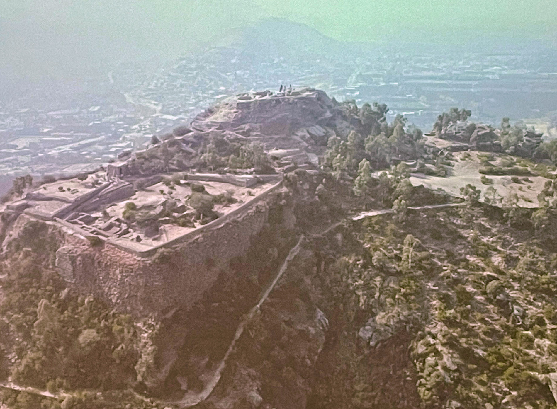
ELISA IORI, Max-Weber-Kolleg, Universität. Erfurt.
Overlapping Landscapes at the City of the Vajra (Barikot, Swat)
 Co-spatiality is defined by the French geographer Jacques Lévy as “une des inter-spatialités caractérisée par la mise en relation de deux espaces occupant la même étendue” (Lévy 2003, 213).
The concept draws on the idea that space, as multi-layered reality, can operate according to different metrics and that each of the spatial layer drawn by real or imagined spatial actions may (or may not) “vertically” interacts with the others, through “switches”, while occupying the same physical extension.
By using the lens of co-spatiality this paper tries to explore the possible connections among different overlapping landscapes (sacred/sacralised, natural, narrative, urban) operating in the hinterland of the city of Barikot/Vajirasthāna “the sthāna of the Vajra/Vajira” (von Hinüber 2020), where the distinctive rocky spur of the city seems to represent the fix reference point of multiple realities.
ANUSHA VIKRAM, University of Hyderabad.
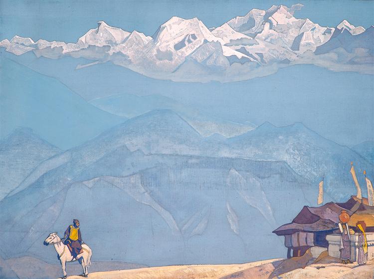
The Substratum of Nicholas Roerich’s Landscape Paintings of Central Asia and the Trans-Himalayas
 Nicholas Roerich’s paintings titled Himalayan Studies is the focus of this paper. Roerich, a Russian émigré artist, travelled 15,000 miles across Central Asia and the trans-Himalayan region from 1924 to 1928. He named his voyage the Central Asian Expedition in his diary. Roerich’s expedition’s landscapes are manifested in two forms – Altai-Himalaya: A travel diary and a set of 500+ tempera paintings. This paper discusses 36 landscape paintings of the expedition that are displayed in Chitrakala Parishath Art Complex in Bangalore and the travel-diary Altai Himalaya to probe the overlapping of painted and textual landscapes.
The paper aims to conduct an in-depth analysis of the landscapes to establish their transnational and transcultural interactions in the Himalayan and Central Asian region. This research departs from the theosophical reading of Roerich’s works in the existing scholarship by using the methodological framework of object studies and transcultural dynamics. The luminescent paintings make the Himalayas accessible, immaterial and utopian. However, the textual landscapes allow a layered insight into the complexities of the quixotic images. Textual landscapes in Altai Himalaya provide the opportunity to view the paintings critically alongside its multicultural dynamics. These landscape paintings are the accounts of diverse people, architecture, daily rituals and religion alongside the intangible, earthly experiences of the Himalayan terrain. Each landscape, textual or pictorial, is an intersection of the divine and human landscapes of the Himalayas.
The presentation will: i) illustrate how the transcultural operates within and through textual and painted landscapes of the Himalayas by Roerich ii) the transformation and interrelation of the Himalayan landscape in the diary and paintings. The prefix trans is crucial to this presentation, encompassing transit, transcultural, transnational and most importantly, transformation in the representation of the Himalayan and Central-Asian landscape.
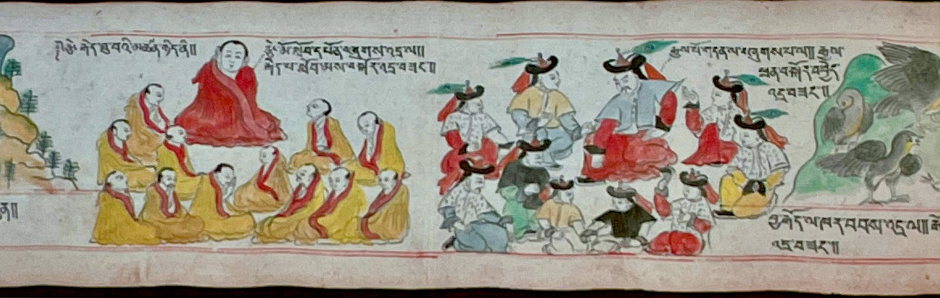
OLAF CZAJA, Akademie der Wissenschaften zu Göttingen.
Presenting Tibet’s India to the British King
 On the 28th of June in 1913 the Tibetan aristocrat Kusho Lungshar, accompanied by four Tibetan boys, had an audience with king George V at Buckingham Palace. He presented him gifts and letters sent by the 13th Dalai Lama. Among the presents was a set of Tibetan paintings (thangkas) depicting the spiritual activities and accomplishments of the seventh Dalai Lama Bskal bzang rgya mtsho. Today this gift is in the collection of the Victoria and Albert Museum in London. (Some single paintings of this popular series can be found in various museums worldwide.)
A thorough examination, discussing in detail its iconography, history and religio-political meaning for the first time, will be at the center of my talk. It will be based on various Tibetan sources such as the biography of the seventh Dalai Lama written by Rol pa’i rdo rje, the seventh Dalai Lama’s writings and so on as well as related pieces of art. One can demonstrate that one of its main features is India as seen in the Dalai Lama’s spiritual imagination that inspired this painting set. One can find it in a reformulation of the Sudhana theme, with the Dalai Lama taking the role of Sudhana, and in the depiction of the pithas with their main tantric practioners based on the visualization of the wheels of mind, body and speech in the Cakrasamvara tantric practice. Seen in this light one may regard it as a proper (religious) gift to the (secular) Emperor of India.
At the end of my talk, I will therefore offer some possible reasons why the 13th Dalai Lama may have regarded this thangka set as a suitable present.
CECILIA DAL ZOVO, Institute of Heritage Sciences, Incipit-CSIC, Santiago de Compostela.
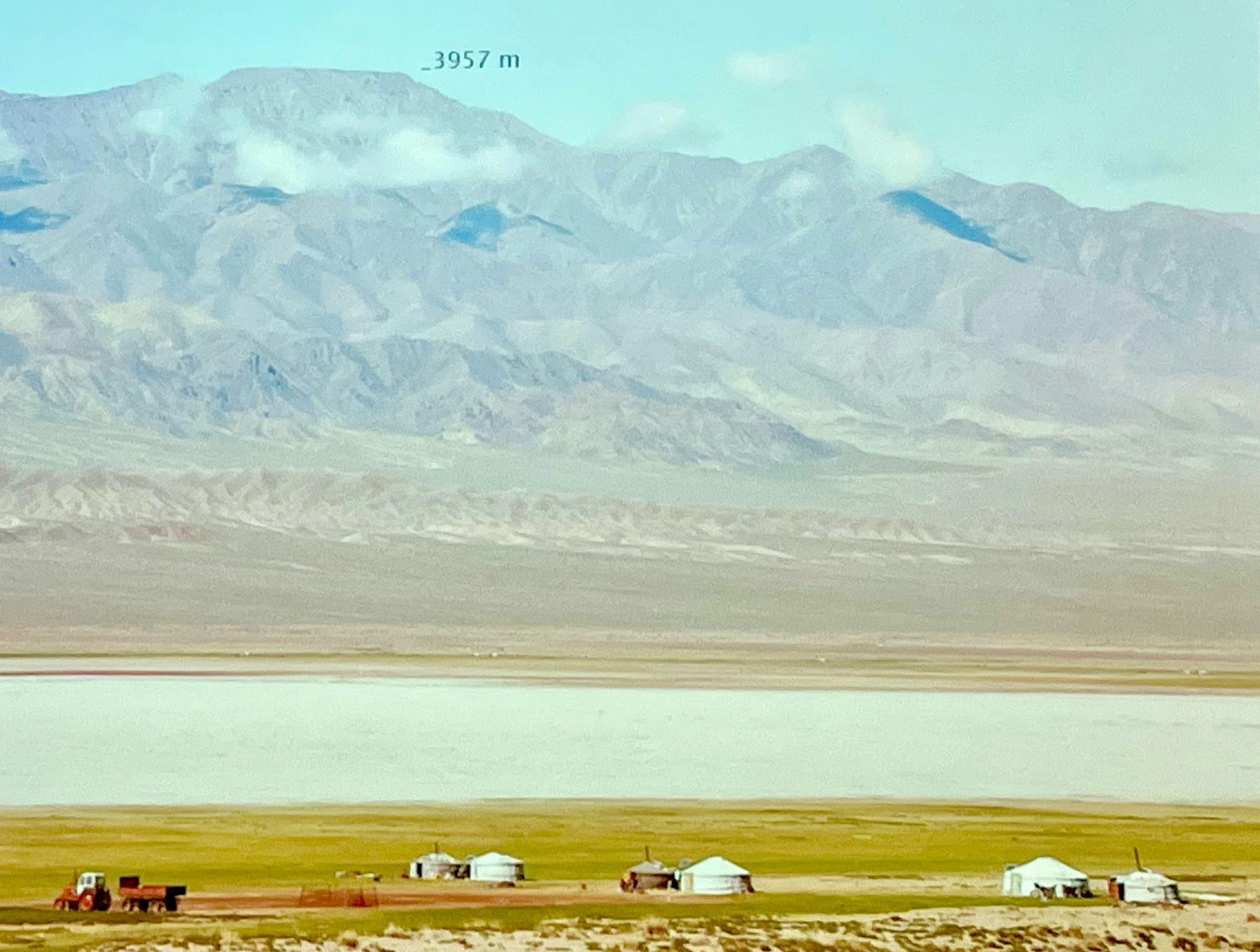
Paths to the Sky: Pastoral and Ritual Mobility in a Sacred Mountain Landscape of Mongolia
 The construction of complex pastoral and sacred geographies in the Eastern Altai Mountains (Mongolia) represents a stimulating research context for interdisciplinary approaches, such as landscape archaeology, which allow us to go beyond the binary categorisation of landscape phenomena. In ancient and modern Mongolia, daily and ritual life traditionally interweaves “in the open”, unlike more monumental or settlement-centred geographies. The divine landscape intensely mirrors many peculiar aspects of the human one, particularly mobility, providing a sense of belonging and identity both at individual and community level. In this paper, I will analyse how the seasonal movement of the herders and their animals could physically and symbolically shape the local landscape. In particular, I will illustrate how the network of paths of thousands of kilometres, which has been mapped through fieldwork and the analysis of satellite images, interconnects pastoral and ritual sites of different epochs across the Ikh Bogd Uul Mountain. In this way, mobility contributes to creating a dynamic and persistent relationship between humans, the landscape, and all creatures and spiritual beings inhabiting it.
AGATA BAREJA-STARZYŃSKA, University of Warsaw.
Buddhist Hellish Landscapes in the Mongolian Tradition – Texts and Images Revisited, Part ½
 Among sources available for the Mongols to learn about Buddhist depictions of hells there are works which belong to the Abhidharma tradition. The paper will discuss the historical development of the Mongolian reception of this tradition represented by the 16th century Čiqula kereglegči tegüs udq -a-tu šastir – “Treatise containing complete meanings of the most important [data] to be used [by a Buddhist]”, written in 1587-1607 by Siregetu guusi corji, most probably a translation of the Tibetan compilation based on the Shes bya rab tu gsal ba by ’Phags pa bla ma (up to 60% of the text), the 17th century Üzeqser tusatai cuxula kereqtü kemekü by the Oirat Zaya Pandita Namkhaijamts (Tib. Nam mkha’i rgya mtsho, 1599-1662) which is similar in content to the Čiqula kereglegči, but contains more detailed information based on different sources, as well as the 18th century Mongolian translation of the Abhidharmakośa included in the Tanjur (Tib. bsTan ’gyur) and several other Mongolian texts which belong to the Buddhist narrative cycles (such as story on Choyijid Dakini etc.). The paper will attempt to compare those depictions with several hell images which were preserved in the Mongolian lands.

MAGDALENA SZPINDLER, University of Warsaw.
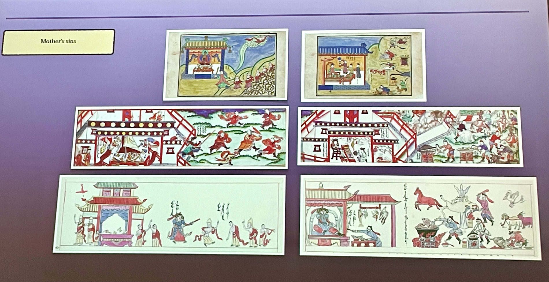
Hellish Landscapes in Molon Toyin’s Sttory: Familiar, Fearsome and Magical, Part 2/2
 For the purpose of my dissertation and currant research project, I have been studying “Molon Toyin’s story,” that is a story of Maudgalyāyana rescuing his mother from hell in Mongolian tradition, but also in Tibetan, since some (or all) of the textual witnesses of the tradition were translated from that language. One of the variants of the story in Mongolian is illustrated, therefore the collation of various manuscripts involves not only texts, but also images. Hellish landscape, which emerges from the books’ pages by means of two complementary medias, the text and image, is in fact hinted to reminding of a theatrical stage rather than any realistic depiction. As such, it fulfils its role by introducing the world “below,” to which one falls into, a full-dimensional airy space in which Maudgalyāyana is flying on a cloud. The story creates a world, which in fact bears similarities to our own world, known to us, yet dangerous. Mountains, ponds, trees, beast-like demons all create a familiar landscape of “wild nature,” magical and fearsome. This imaginary looming from the Molon Toyin’s story I would like to present, the way it is revealed in various texts and illustrations, pointing also to some similarities and differences in comparison to other sources of hellish imaginary known from the Mongolian tradition.
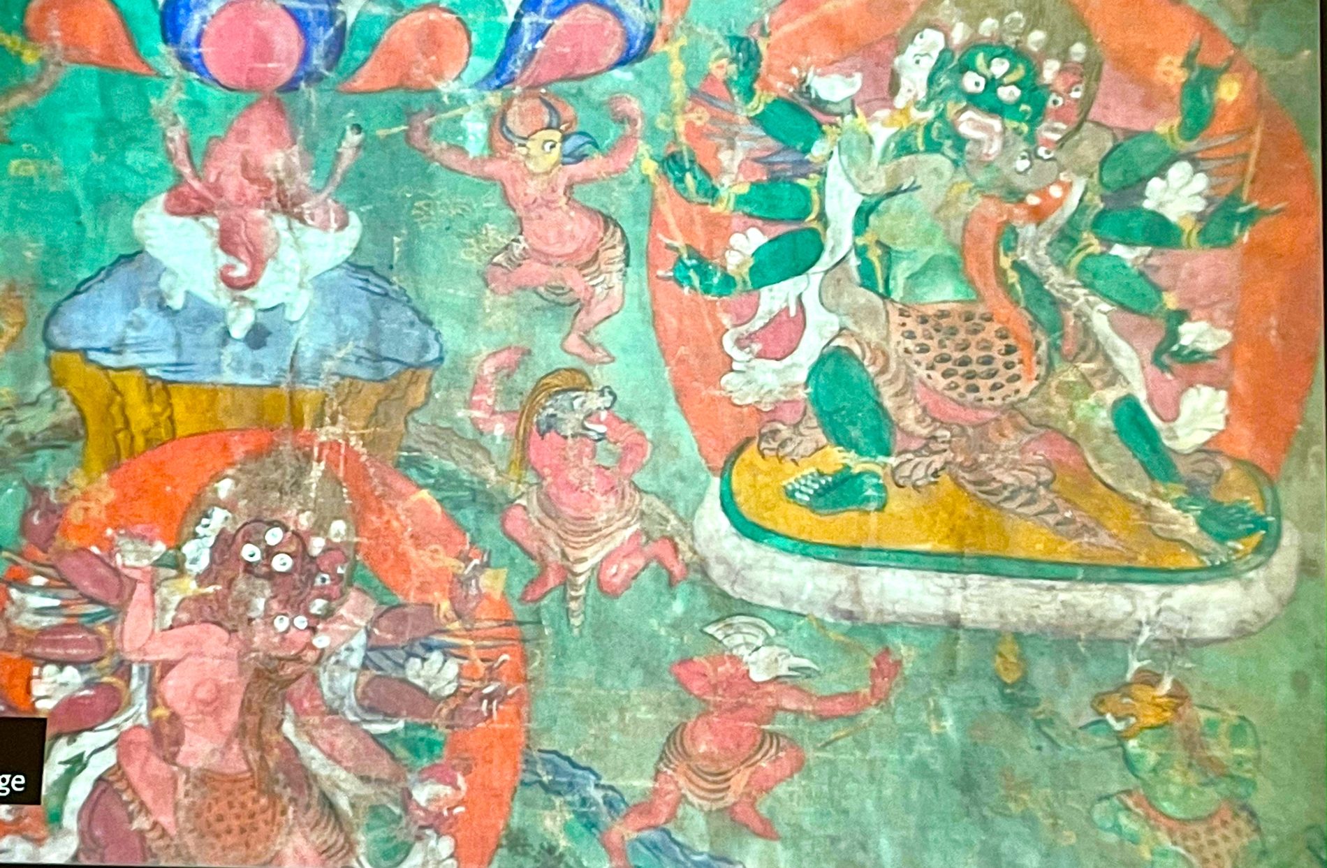
GERALD KOZICZ, Technische Universität Graz.
The Landscape Mandala of the Assembly of the 100 Peaceful and Wrathful Deities
 In Tibetan Buddhism, the period between death and rebirth is considered a phase of transition commonly known as the Bardo. During this phase one expects to be confronted with various forms of positive and negative energies which one has to cope with according to one’s karma and spiritual strength. In text and art, these spiritual forces were described and visualized as deified figures. In accordance with a common practice of mandalafication, the assembly was understood as the Mandala of the 100 Peaceful and Wrathful Deities. In contrast to the usual pattern, this assembly was never configured as a single-centered mandala but divided in two sections: the 42 peaceful deities headed by Samantabhadra in union with Samantabhadrī, and the 58 wrathful deities under the leadership of Mahottra Heruka embracing Krodeśvari. In art – e.g. in mural painting –, the two groups were usually presented side by side. Another striking deviation from the convention is the complete absence of architectural elements as a structural device to bring order to the assembly. Instead, that assembly was normally embedded in a landscape.
This paper sets out to investigate how landscape features were applied to create hierarchy and add meaning to such overall mandala configurations, and how the depiction of additional ritual objects within the landscape and their symbolism enhanced their functional and explanatory aspect. Through a comparative study the paper will further attempt to explain why a landscape was a deliberate choice instead of a strictly geometric, centered mandala palace. The presentation will discuss several horizontal mandalas documented in temples of Kinnaur, four spatial mandalas inside lantern ceilings of stupas in Nubra, and a twin-set thangka from a private family shrine in Nubra.
MARTA SERNESI, École Pratique des Hautes Études, Paris.
Tsib-ri Hermits and Hermitages: Historical Religious Landscape in South-Western Tibet
 Tsib-ri is the sacred mountain of the region of Southern La-stod in south-western Tibet, facing Mt. Everest. As was pointed out in the pioneering ethnographic study by Barbara Nimri Aziz (1978), during the early 20th century most of the celibate monks’ settlements of the region were situated on the massif, while the nearby villages hosted temples looked after by non-celibate religious specialists. Historical research shows that the mountain was set apart from rural life early on, as a chosen spot for intensive practice retreats. Indeed, between the 12th and the 14th century, on this rocky landscape dwelled a small religious community that built hermitages and transmitted different methods of realisation in an eclectic environment. These were combined into the so-called “Mountain Teachings” (Ri chos) by Yang-dgon-pa rGyal-mtshan dpal-bzang-po (1213–1258), a collection of instructions for solitary meditation retreats in the wilderness. This talk will outline the development of this hermitic tradition mapping it on the rugged terrain of Tsib- ri.
DIANE ZHANG-GOLDBERG, Institut Catholique de Paris / Centre de Recherche sur les Civilisations de l’Asie Orientale, Paris.
Weaving Heterogeneous Landscapes: Tangut Depiction of Deities within Terrestrial Landscapes and Integration of Sacred Landscapes in Funerary Architecture
 Two locations play a recurring role in Tangut culture: Mount Wutai and Amitābha’s Pure Land. The former is real but in China, far away from the Xixia empire; the latter is mythical and became a cornerstone of Xixia Buddhism. This paper will show how these two landscapes contributed to the elaboration of sophisticated Xixia works of art, which intertwine natural, human and divine elements in a very distinctive way.
It will highlight that both have a defining role in the imperial cemetery. The dynastic necropolis was indeed erected at the foot of the Helan Mountain, a sacred mountain range where Xixia built their own “Mount Wutai of the East” after China forbade them from visiting Mount Wutai. Moreover, one striking feature of the cemetery is the presence of kalavinkas in tomb n°3, which is very uncommon in Chinese and Central Asian architecture. Associated with other architectural elements, not only does it suggest that the defunct was a devotee to Amitābha, but that his tomb was devised as a replica of the Pure Land he intended to reach.
Amitābha’s Pure Land is also evoked in numerous Tangut paintings, but in rather conventional ways. On the contrary, two late Xixia mural paintings in Yulin Cave 3, depicting Samantabhadra and Mañjuśrī, deserve attention because the deities seem to be included into a landscape, which is unique in Yulin’s Buddhist paintings. This paper will outline the Song inspired naturalist style, the emphasis on mountains, and the integration of detailed architectures into the background, that set these works apart. It will also focus on the Mañjuśrī painting background, which is considered to be Mount Wutai: this painting indubitably represents a terrestrial landscape; but does it depict the original Mount Wutai, its Tangut recreation, or a fantasied version of this place?
DAVID C. ANDOLFATTO, Musée du quai Branly–Jacques Chirac, Paris.
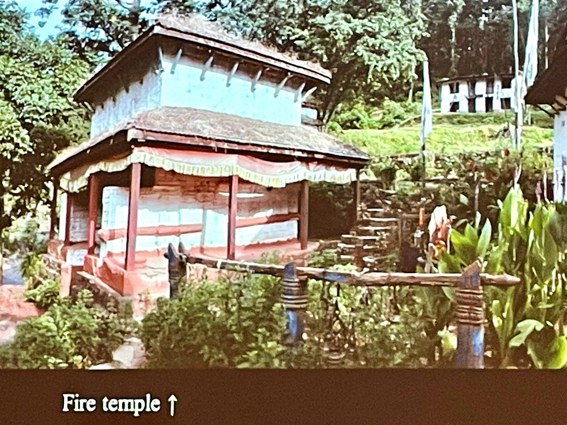
The Archaeology of the Fire Temples of Dullu, West Nepal
 The communication will present a central Himalayan pilgrimage center, famous for its natural gas flames and locally known as the Dullu Pancakoshi. As pointed out by Marie Lecomte-Tilouine in her historico-religious study of the area, the fire temples created a sacred landscape at the center of which the Khasa Malla emperors (12th-14th century) established one of their capitals. Although so far no subsurface archaeological research has been conducted, yet architectural and sculptural remains scattered on the five main sites and on secondary ones indicate the importance of this pilgrimage. A thorough surface field survey of the vestiges allows to draw a better picture of who visited the sites (Hindus, Buddhists and Jains). The presentation will show that the flow of pilgrims, continuous up until the 18th-19th century, supported the creation of local artistic workshops. Likewise, a typological and statistical approach of archaeological remains will reveal that the sites were in fact crowded by numerous medieval temples erected in the memory of deceased individuals.
Finally, I will present an overlooked map of the area published in the 18th century by Abraham Hyacinthe Anquetil-Duperron.
AMY HELLER, Universität Bern / Centre de Recherche sur les Civilisations de l’Asie Orientale, Paris.
Human Landscapes from Early Tibet
 In this presentation I propose to examine archaeological artefacts which reflect aspects of human landscapes during the Tibetan empire.
Further to my earlier research on painted Tibetan coffins (Heller 2012; Heller 2016), I pursued research on birds and deer based on fragments of early Tibetan rituals, Dunhuang manuscript illustrations and archaeological artefacts found in Guge, central Tibet and along the Silk roads (Heller 2018, Heller in press).
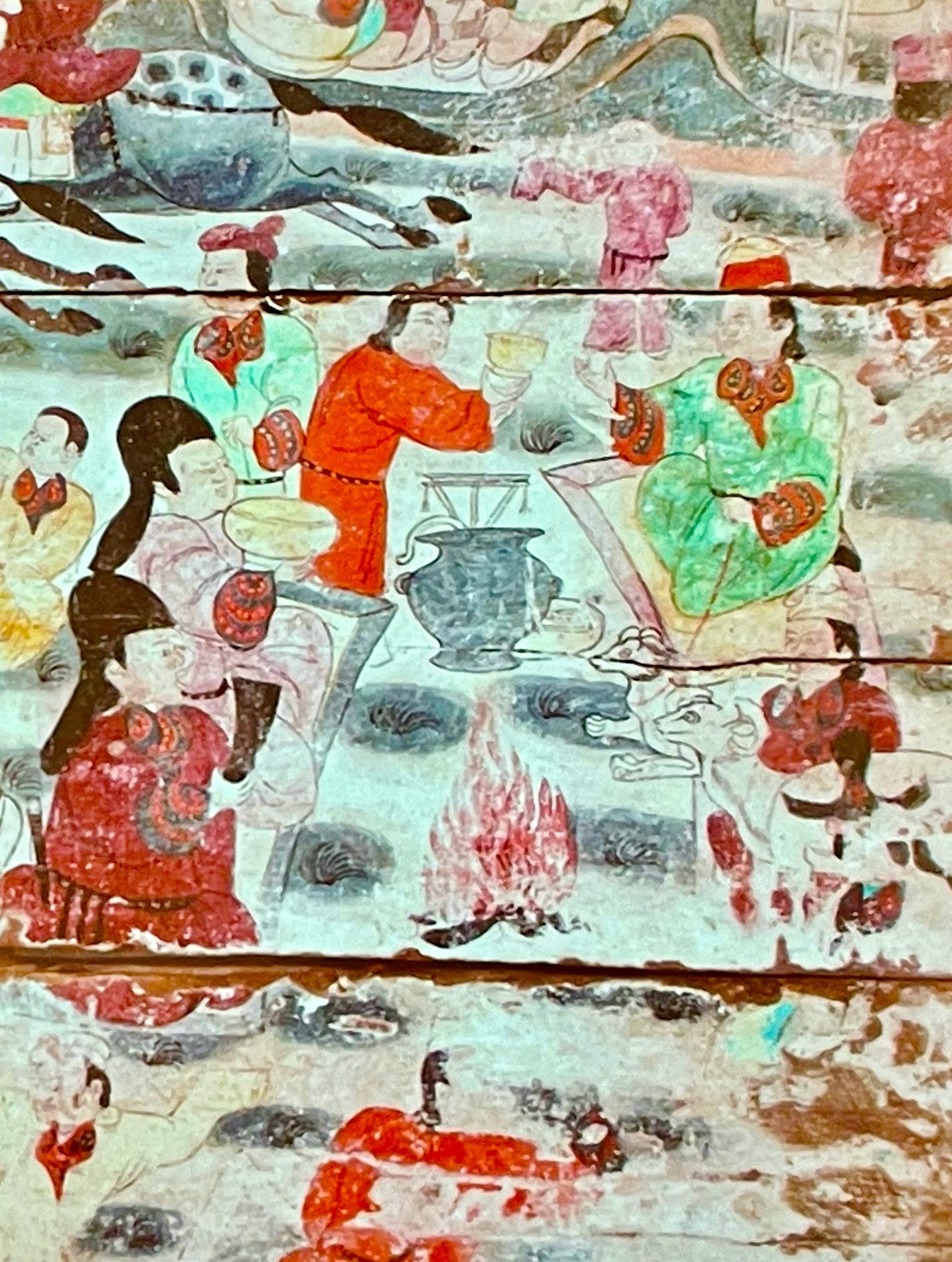
The ideal landscapes represented on the painted coffins of the Tibetan empire are also found on mural paintings in tombs in Qinghai, documented notably by Tong Tao and Xu Xinguo (2012), and Zhang Jianling and Tshelothar (2019). Thematically we find scenes of royal hunt of deer and yak, processions, ceremonies of homage, banquets, ribaldry, musicians and dancers as well as cranes in flight, flocks of birds, herds of goats, aspects of daily life of nomadic people. There are also specific elements which evoke funerary rituals and Zoroastrian ritual cults. The analysis of the content of these human landscapes in terms of art history and ritual brings insights on the multi-cultural interactions amongst Tibetans with other populations encountered along the Silk Route and the caravan routes linking Central Asia and the Himalayas.
DIANA LANGE, Universität Hamburg.
The Diverse Mapping of Tibetan Human Landscapes
 Particularly since the 18th century, Tibetan landscapes have been mapped in different “cartographic languages” that resulted in different visual representations of the area. The maps made by Europeans in the “Western scientific way” of mapping look very abstract. Maps made in the autochthon and “analytical” Chinese way – based on measurements undertaken during surveys – look more pictorial but also include abstract elements. Maps made by the Tibetans in the autochthon Tibetan “descriptive way of mapping” look like living landscapes. The graphic content and the language are central to the identification of individual maps and can provide insights in the concept and system of rules, ideas and beliefs that led to their production. The case of Tibet is of special interest in the context of mapmaking, as here we deal with multi-directional interaction between Tibet, China and the “West”. In my talk I want to discuss how spatial information of a specific region was conveyed in different cartographic languages, how these different languages influenced each other and how “translations” between different cartographic languages led to the production of hybrid maps.
BRIGITTE STEINMANN, Université de Lille.
The Multiple Dimensions of the Construction of a “Hidden Landscape” on the Borders of the Three Ancient Himalayan Kingdoms (Tibet, Sikkim, Nepal)
 The way of imagining, building and describing “landscapes” is the most contentious thing in the world: where some prehistorians see, for instance, in a cave painted with rock figures a place of shamanic meeting, others see it as a simple refuge from wild animals. Recognizing that any perception is social does not necessarily mean that it is uniform or consensual. Its symbolic reconstruction always gives way to a great diversity of forms of imagination.
With this in mind, we choose the example of the multiple representations of Tibetan hidden countries, sBas yul, to highlight the meaning of the “hidden” dimension of any landscape, as it reads through a double figure: that of the imaginary, by definition unlimited, and that of travels in any country, “beyond” known limits.
From a long ethnographic inquiry around Kanchenjunga mountain in the Himalayas, we study the multiple dimensions of landscapes at the eastern borders of the three ancient Tibetan, Sikkimese and Nepalese kingdoms. From the 17th century, it was under the sign of the sBas Yul that several forms of centralizations, religious, state-administrative and “visionary”, of Mongolian and Indian inspiration, were established at the same time in these borders, by Tibetan lamas and arhat, Chogyal of Sikkim, and local religious Nepalese chiefs.
From the descriptions of the religious and secular travels between these borders “around the Kanchenjunga”, can be read as many visions and descriptions of material and spiritual wealth of lands, that did not yet have the name of “country”. Their tangled meanings are united in the theme of the absence of any “territorial” consciousness, and opposed experiences of magical paths: arhat flying over the mountains, Lepcha indigenous ancestors traveling underground corridors. The paradox remains that of the extreme precision of physical, geographical, botanical, zoological knowledge, presiding over all these stories and relations.
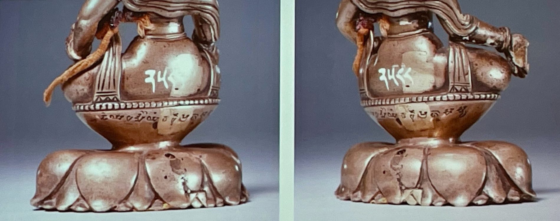
HAYAN HU-VON-INHÜBER, Max-Weber-Kolleg, Universität Erfurt.
Two Newly Found Bronze Statues with Sanskrit Inscription Originating from Historical Northwest India
 The paper aims to discuss two ancient bronze statues depicting Bodhisattvas, which have recently been discovered. Both bronzes noticeably originate from the area in the northwest of ancient India. Due to the observed deviation in artistic style and a few specific references to the location of the finds, this vast area in the western Himalayas has often been divided by archaeologists and art historians into two main groups: the greater area of Swat/Gandhāra and the greater area of Kashmir/Gilgit.
The studies focus, first of all, on the Sanskrit inscriptions that both bronzes provide us with. Based on the paleographic analysis of the “Proto-Śāradā” script type, which was widely used in the various areas of historical northwest India, both bronze images examined here are datable to the first half of the 7th century. From the last decades of the 6th century to the first decades of the 8th century, the royal family Palola Şāhis ruled the area of Gilgit and beyond. Concerning the relationship of the Palola Şāhis with the art tradition in Tibet, “one might at least assume that some, if not all of the bronzes were taken to Tibet over the course of the Tibetan campaigns around 720 CE and the eventual conquest of Balūr around 745 CE … This art tradition seems to build a bridge between the Gandhāra art from which only a few bronzes have remained, and the bronze casting in Tibet which gradually began during this period” (O. von Hinüber 2004, Die Palola Şāhis, p. 9).
In collaboration with the Research Institute for Tibetan Buddhist Heritage of the Palace Museum (Peking), a number of newly uncovered Indian bronzes, which are equipped with Sanskrit inscriptions and mainly kept in Tibetan monastic collections in China have been investigated within the framework of the paleographic and historical perspective. As the “first-hand material”, the bronze sculptures examined in this cooperating project can be regarded as supplements to the largest corpora documenting the Indo-Tibetan sculptures which were published by U. von Schröder in 2001 (Buddhist Sculptures in Tibet, 2 vols.) and previously in 1981 (Indo-Tibetan Bronzes).
PETRA MAURER, Bayerische Akademie der Wissenschaften, München.
Ways of Looking at the Landscape in the Tibetan Geomancy (sa dpyad)
 Criteria for the examination and assessment of a construction site, whether for the construction of sacral and secular buildings provides Tibetan geomancy (sa dpyad). As a topic of the so-called “Chinese calculations” (nag rtsis) if forms together with astronomy, mathematics and other types of divination one of the traditional sciences that were introduced during the Yarlung or Spu rgyal Empire (8th century). Geomantic principles determine where to construct monasteries, hermitages and chörten, as well as dwellings for the living and graves for the dead.
The examination of a site requires skills in the analysis of the topographical environment and the calculation of the dimensions related to the birth date (such as zodiac signs, elemental phases, planets) of the future inhabitant.
To select a suitable site, the geomancer focuses on recognizing specific shapes of mountains, rocks, and river courses that influence or even determine the land’s effect on its inhabitants. The land with its single topographical aspects such as the mountains and rivers is not generally assessed as sacred, it’s their shape and direction that determine their suitability as construction site. The right interpretation of these shapes, their recognition as benevolent or hostile for humans grants health and survival. In a second step, the geomancer calculates specifically the temporal aspects of the client or future inhabitant, that is to say the relation between the birth time and the construction time. Hereby, their interrelation and their relation with topographic aspects of a site determine the relationship between the client, i.e. the human being and the respective site. That is to say, place and time determine the intricate relation of humans with their natural environment. Hence, the environment provides the conditions humans should adopt to, conditions that can occasionally be influenced by human action, for example, ritual.
In this paper, I will introduce the main theories of Tibetan geomancy with its ways of looking at a site or the “landscape”, including the human’s possibilities of interaction with the environment. I will reflect on the question whether these concepts contain remnants of the notion of an animate environment as it was known in pre-Buddhist Tibet.
CHARLES RAMBLE, École pratique des hautes études – PSL / Centre de Recherche sur les Civilisations de l’Asie Orientale, Paris.
The Many Mansions of a Tantric Divinty of the Tibetan Bon Religion
 The tantric divinity Trowo Tsomchog Khagying, classed as one of the “Five Supreme Citadels (gSas mkhar mchog lnga)”, is one of the most important deities in the pantheon of the Bon religion of Tibet. In visual representations, Tsomchog appears in settings – landscapes, so to speak – of varying degrees of abstraction. At one extreme there is his mandala, which, as is usual in Bon, he and the members of his large entourage and the spheres they inhabit are represented aniconically, in syllables, colours and geometric forms. The iconography of the god has been the subject of four previous studies (two by Per Kvaerne, one each by Amy Heller and the present author), based on different thangkas in which he is represented at the centre, in union with his consort, surrounded by the different classes (some apparently unique to his tantric cycle) and animals that make up his cosmos. In sādhana ritual performances, his mandala is given a much more concrete, three-dimensional form with elaborate dough-and-butter effigies (tormas) of the major and minor divinities in their appropriate positions on the stages of the “altar”. But Tsomchog also has a terrestrial abode in one of the peaks of Kongpo Bonri, the Bon Mountain of Kongpo, the most sacred pilgrimage destination for followers of the Bon religion, located in southeast Tibet. Tsomchog’s association with this site goes back to at least the twelfth century: in the gZer mig, a hagiography of the life of Shenrab Miwo, revered as the founder of the Bon religion who (according to this account), the hero travels to the demonic land of Kongpo with a view to converting it to the Bon religion. During his epic battle with the autochthonous demons of Kongpo, Shenrab emanates a ray of light that crystallises in the form of Tsomchog, whose presence in the mountain is the first step in the historical “mandala-isation” of the surrounding topography according to subsequent literary and visual representations. This story has generated scroll paintings (thangkas) and block prints that depict Tsomchog at the centre of this terrestrial mandala, the Bon Mountain, surrounded not by his usual entourage of divinities but by the historical saints, pilgrims, temples and other holy sites that came to be associated with this real-world location. This presentation will reflect on what this multiplicity of environments in which Tsomchog manifests might contribute to scholarly understandings of the concept of sacred landscape.
ANTJE LIKENBACH, Max-Weber-Kolleg, Universität Erfurt.
Travelling Deities: The Spatial-Political Dimension of Religion in Uttarakhand (India)
 While the Indian state of Uttarakhand, located in the Central Himalayas, is the land of the Char dham (four abodes or pilgrimage centers) and thus place and destination of those who worship the major Hindu gods and follow mainstream Hindu religiosity, it is equally an area with multiple regional and local Hindu deities and particular forms of worship.
The paper will present the cult of three regional deities in western Garhwal and their historical and contemporary relationship to territory, politics and power. Each of the gods controls a particular territory and affirms his realm of influence by an annual journey (yātrā), when an image (mūrti) of the god is carried in a palanquin (ḍolī) from village to village, and a festival (mela) near the deities’ forest temples, visited by worshippers from the surrounding villages. Oral narratives memorize the histories of origin of the gods and their historic relationship to political structures and power dynamics. The paper will also reflect on the parallels that emerge between the deities’ reign and the structures and functioning of the traditional form of western Himalayan kingship. The main research in the region was carried out between 1993 and 2000, with continuous follow-ups. The lived religion as it exists still today in the villages creates and re-creates a sacred geopolitical space of contested divine supremacy and validates the territorial claim and the power of the divine through mobility (of gods and people).